
Bathurst topographic map
Interactive map
Click on the map to display elevation.
About this map
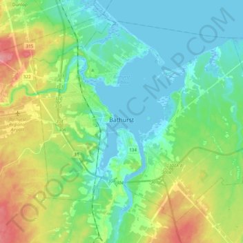
Name: Bathurst topographic map, elevation, terrain.
Average elevation: 26 m
Minimum elevation: -5 m
Maximum elevation: 88 m
Other topographic maps
Click on a map to view its topography, its elevation and its terrain.
Pabineau Falls
Canada > New Brunswick > Bathurst Parish
Pabineau Falls, Bathurst Parish, Gloucester County, New Brunswick, Canada
Average elevation: 47 m
Chamberlain Settlement
Canada > New Brunswick > Bathurst Parish
Chamberlain Settlement, Bathurst Parish, Gloucester County, New Brunswick, E2A 3Z2, Canada
Average elevation: 46 m