
Campbell River topographic map
Interactive map
Click on the map to display elevation.
About this map
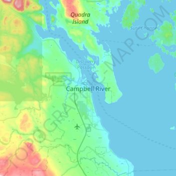
Name: Campbell River topographic map, elevation, terrain.
Location: Campbell River, British Columbia, V9W 4C7, Canada (49.86307 -125.40415 50.18307 -125.08415)
Average elevation: 108 m
Minimum elevation: -2 m
Maximum elevation: 829 m
British Columbia trails, hiking, mountain biking, running and outdoor activities
Other topographic maps
Click on a map to view its topography, its elevation and its terrain.