
La Montagne noire topographic map
Interactive map
Click on the map to display elevation.
About this map
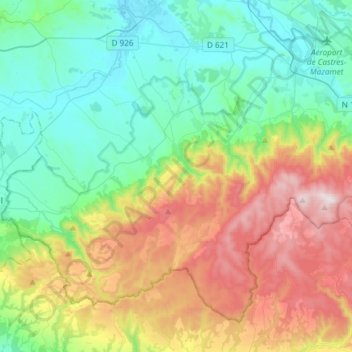
Name: La Montagne noire topographic map, elevation, terrain.
Location: La Montagne noire, Tarn, Occitania, Metropolitan France, France (43.38282 2.01362 43.56409 2.31115)
Average elevation: 440 m
Minimum elevation: 160 m
Maximum elevation: 1,033 m
Other topographic maps
Click on a map to view its topography, its elevation and its terrain.
Saint-Hyppolyte
France > Occitania > Tarn-et-Garonne > Bouloc-en-Quercy > Bouloc > Saint-Hyppolyte
Average elevation: 176 m
Luchon-Superbagnères
France > Occitania > Haute-Garonne > Saint-Aventin > Luchon-Superbagnères
Average elevation: 1,331 m