
Pamlico County topographic map
Interactive map
Click on the map to display elevation.
Pamlico County
The county was formed in 1872 from parts of Beaufort and Craven counties. It was named for Pamlico Sound, which adjoins it. Vernacular usage in the area, especially in Craven County, refers to Pamlico County as being "down in the county." Prior to 1872, it was a part of Craven County and has a very low elevation. Most of the county, according to FRIS, North Carolina Flood Risk Information System, is subject to flooding in storm surges. After it was separated from Craven, the old nickname survives. Pamlico County remains rural in character and flavor, although the last decade has brought a good deal of residential development, largely the result of northern retirees and investors attracted to the many miles of waterfront property.
About this map
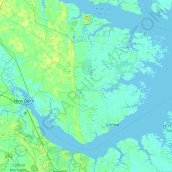
Name: Pamlico County topographic map, elevation, terrain.
Location: Pamlico County, North Carolina, United States (34.95030 -76.98758 35.36043 -76.30414)
Average elevation: 5 m
Minimum elevation: -11 m
Maximum elevation: 39 m
Other topographic maps
Click on a map to view its topography, its elevation and its terrain.