
Nederland topographic map
Interactive map
Click on the map to display elevation.
About this map
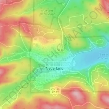
Name: Nederland topographic map, elevation, terrain.
Location: Nederland, Boulder County, Colorado, 80466, United States (39.95498 -105.52334 39.97532 -105.48418)
Average elevation: 2,578 m
Minimum elevation: 2,482 m
Maximum elevation: 2,677 m
In 1873 the Caribou Mine, at an elevation of roughly 10,000 feet (3,000 m) and 6 miles (10 km) northwest of the town, was sold to the Mining Company Nederland from the Netherlands. The high elevation meant fierce winds and deep winter snow, so the new owners of the mine decided that it was beneficial to bring ore from Caribou down to Middle Boulder for milling. In the Dutch language, Nederland ("Netherlands" in English) means low land, and based on casual usage by the Dutch miners, Middle Boulder came to be known as Nederland. In 1874 the town was incorporated and adopted Nederland as the official name.
Other topographic maps
Click on a map to view its topography, its elevation and its terrain.
Longmont
United States > Colorado > Boulder County
Longmont, Boulder County, Colorado, United States
Average elevation: 1,534 m
Hecla Lake
United States > Colorado > Boulder County > Louisville
Hecla Lake, Louisville, Boulder County, Colorado, United States
Average elevation: 1,624 m
Lyons
United States > Colorado > Boulder County
Lyons, Boulder County, Colorado, United States
Average elevation: 1,690 m
Albion Lake
United States > Colorado > Boulder County
Albion Lake, Boulder County, Colorado, United States
Average elevation: 3,497 m
Hidden Lake
United States > Colorado > Boulder County
Hidden Lake, Boulder County, Colorado, United States
Average elevation: 2,679 m
Boulder
United States > Colorado > Boulder County > Boulder
Boulder, Boulder County, Colorado, 80306, United States
Average elevation: 1,977 m
Boulder
United States > Colorado > Boulder County
Boulder, Boulder County, Colorado, United States
Average elevation: 1,786 m
Longs Peak
United States > Colorado > Boulder County
Longs Peak, Boulder County, Colorado, United States
Average elevation: 3,825 m