
Kisumu topographic map
Interactive map
Click on the map to display elevation.
About this map
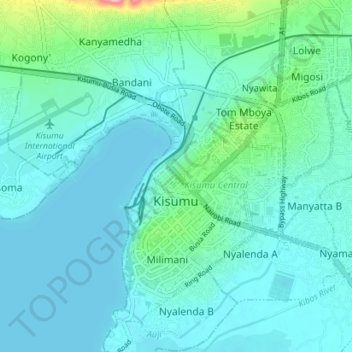
Name: Kisumu topographic map, elevation, terrain.
Location: Kisumu, Nyanza, 40100, Kenya (-0.13318 34.74200 -0.06258 34.79160)
Average elevation: 1,155 m
Minimum elevation: 1,132 m
Maximum elevation: 1,294 m
The name Kisumu literally means a place of barter trade "sumo". The city has "Friendship" status with Cheltenham, United Kingdom and "sister city" status with Roanoke, Virginia and Boulder, Colorado, United States. Its elevation is 1,131 m (3,711 ft) above sea level. Kisumu is about 320 km (200 mi) northwest of Nairobi and its located at the shores of Lake Victoria. It lies at the northeastern edge of the Winam Gulf, a long, shallow arm that protrudes from the main body of Lake Victoria. Kisumu is set 24 km (15 mi) south of the Equator and has moderate temperatures because of its 1130 m elevation. Just four hours away by car is the massive Kenya National Game Preserve: the Maasai Mara, a world-renowned safari attraction. Since Kisumu is a few kilometers south of the Equator, daytime there always lasts about 12 hours, and local sunset always occurs between 18:40 and 19:00 local time. The metropolitan region comprises the city and its suburbs and satellite towns of Maseno, Kondele, and Ahero.