
Moroni topographic map
Interactive map
Click on the map to display elevation.
About this map
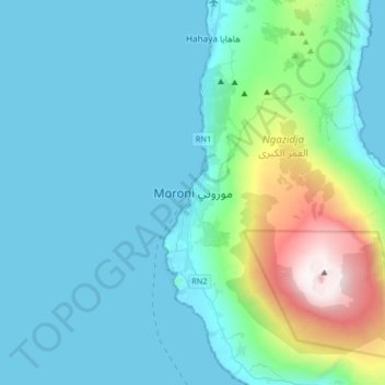
Name: Moroni topographic map, elevation, terrain.
Location: Moroni, Grande Comore, 442, Comoros (-11.85313 43.09430 -11.53313 43.41430)
Average elevation: 351 m
Minimum elevation: 0 m
Maximum elevation: 2,354 m
Other topographic maps
Click on a map to view its topography, its elevation and its terrain.
Mount Karthala
Comoros > Grande Comore > Moroni
Mount Karthala, Moroni, Grande Comore, Comoros
Average elevation: 2,248 m