
Make a donation
Gear up for your next adventure:
As an Amazon Associate, this site earns from qualifying purchases at no extra cost to you.
Srivilliputtur topographic map
Click on the map to display elevation.
Make a donation
Gear up for your next adventure:
As an Amazon Associate, this site earns from qualifying purchases at no extra cost to you.
Srivilliputtur
Srivilliputtur is located at 9°30′58″N 77°37′48″E / 9.5161°N 77.63°E / 9.5161; 77.63. The town is located at the foothills of the Western Ghats 77 km (48 mi) south west of Madurai. It has an average elevation of 137.2 metres (450 ft) above mean sea level. There are no notable mineral resources available in and around the town. Srivilliputtur receives scanty rainfall with an average of 811 mm (31.9 in) annually, which is lesser than the state average of 1,008 mm (39.7 in). The South west monsoon, with an onset in June and lasting up to August, brings scanty rainfall. Bulk of the rainfall is received during the North East monsoon in the months of October, November and December.
Make a donation
Gear up for your next adventure:
As an Amazon Associate, this site earns from qualifying purchases at no extra cost to you.
About this map
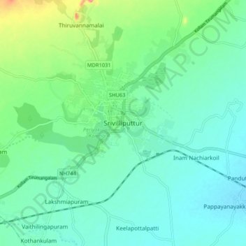
Name: Srivilliputtur topographic map, elevation, terrain.
Average elevation: 149 m
Minimum elevation: 128 m
Maximum elevation: 217 m
Make a donation
Gear up for your next adventure:
As an Amazon Associate, this site earns from qualifying purchases at no extra cost to you.