
District of Sfakia topographic map
Interactive map
Click on the map to display elevation.
About this map
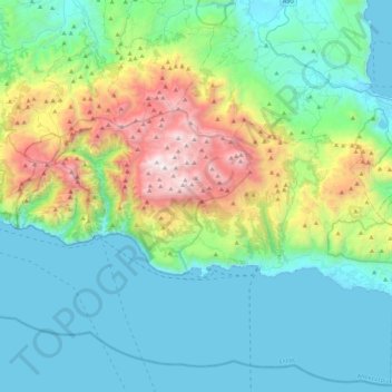
Name: District of Sfakia topographic map, elevation, terrain.
Average elevation: 553 m
Minimum elevation: -1 m
Maximum elevation: 2,441 m
Other topographic maps
Click on a map to view its topography, its elevation and its terrain.
Agios Nikolaos
Greece > Region of Crete > Lasithi Regional Unit > Agios Nikolaos Municipal Unit
Average elevation: 70 m
Hamilon
Greece > Region of Crete > Lasithi Regional Unit > Agios Nikolaos Municipal Unit > Hamilon
Average elevation: 191 m
Istro
Greece > Region of Crete > Lasithi Regional Unit > Agios Nikolaos Municipal Unit > Istro
Average elevation: 89 m
Selena
Greece > Region of Crete > Lasithi Regional Unit > Agios Nikolaos Municipal Unit
Average elevation: 1,167 m