
Make a donation
Gear up for your next adventure:
As an Amazon Associate, this site earns from qualifying purchases at no extra cost to you.
District of Sfakia topographic map
Click on the map to display elevation.
Gear up for your next adventure:
As an Amazon Associate, this site earns from qualifying purchases at no extra cost to you.
About this map
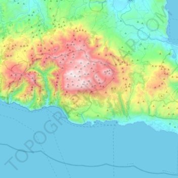
Name: District of Sfakia topographic map, elevation, terrain.
Average elevation: 553 m
Minimum elevation: -1 m
Maximum elevation: 2,441 m
Make a donation
Gear up for your next adventure:
As an Amazon Associate, this site earns from qualifying purchases at no extra cost to you.
Other topographic maps
Click on a map to view its topography, its elevation and its terrain.
Agios Nikolaos
Greece > Region of Crete > Lasithi Regional Unit > Agios Nikolaos Municipal Unit
Average elevation: 70 m
Selena
Greece > Region of Crete > Lasithi Regional Unit > Agios Nikolaos Municipal Unit
Average elevation: 1,167 m
Make a donation
Gear up for your next adventure:
As an Amazon Associate, this site earns from qualifying purchases at no extra cost to you.
Istro
Greece > Region of Crete > Lasithi Regional Unit > Agios Nikolaos Municipal Unit > Istro
Average elevation: 89 m
Hamilon
Greece > Region of Crete > Lasithi Regional Unit > Agios Nikolaos Municipal Unit > Hamilon
Average elevation: 191 m