
Sweet Bay topographic map
Interactive map
Click on the map to display elevation.
About this map
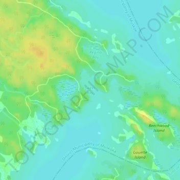
Name: Sweet Bay topographic map, elevation, terrain.
Average elevation: 185 m
Minimum elevation: 177 m
Maximum elevation: 199 m
Other topographic maps
Click on a map to view its topography, its elevation and its terrain.
Go Home Lake
Canada > Ontario > Georgian Bay Township
Go Home Lake, Lagoon Road, Georgian Bay Township, District Municipality of Muskoka, Muskoka District, Central Ontario, Ontario, Canada
Average elevation: 192 m
Gloucester Pool
Canada > Ontario > Georgian Bay Township
Gloucester Pool, Rocky Shore Road, Georgian Bay Township, District Municipality of Muskoka, Muskoka District, Central Ontario, Ontario, L0K 1S0, Canada
Average elevation: 186 m
Turtle Island
Canada > Ontario > Georgian Bay Township
Turtle Island, Georgian Bay Township, District Municipality of Muskoka, Muskoka District, Central Ontario, Ontario, Canada
Average elevation: 194 m
Stewart Lake
Canada > Ontario > Georgian Bay Township
Stewart Lake, Stewart Lake Road, Georgian Bay Township, District Municipality of Muskoka, Muskoka District, Central Ontario, Ontario, Canada
Average elevation: 241 m
Toronto Lake
Canada > Ontario > Georgian Bay Township
Toronto Lake, Muyers Lake Road, Georgian Bay Township, District Municipality of Muskoka, Muskoka District, Central Ontario, Ontario, Canada
Average elevation: 239 m