
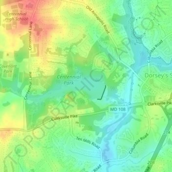
Centennial Lake topographic map
Interactive map
Click on the map to display elevation.
About this map
Name: Centennial Lake topographic map, elevation, terrain.
Average elevation: 116 m
Minimum elevation: 91 m
Maximum elevation: 151 m
Other topographic maps
Click on a map to view its topography, its elevation and its terrain.
Elkridge
United States > Maryland > Howard County
Elkridge, Howard County, Maryland, 21075, United States
Average elevation: 39 m
Ellicott City
United States > Maryland > Howard County
Ellicott City, Howard County, Maryland, 21043, United States
Average elevation: 119 m
Elkridge
United States > Maryland > Howard County > Hanover
Elkridge, Hanover, Howard County, Maryland, 21075, United States
Average elevation: 59 m
Highland
United States > Maryland > Howard County
Highland, Howard County, Maryland, 20777, United States
Average elevation: 139 m
Clarksville
United States > Maryland > Howard County
Clarksville, Howard County, Maryland, 21029, United States
Average elevation: 134 m
Ellicott City
United States > Maryland > Howard County > Ilchester
Ellicott City, Ilchester, Howard County, Maryland, United States
Average elevation: 123 m