
Stroud topographic map
Interactive map
Click on the map to display elevation.
About this map
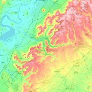
Name: Stroud topographic map, elevation, terrain.
Location: Stroud, Gloucestershire, England, United Kingdom (51.58984 -2.54081 51.85046 -2.06871)
Average elevation: 113 m
Minimum elevation: 0 m
Maximum elevation: 302 m
Other topographic maps
Click on a map to view its topography, its elevation and its terrain.
Cooper's Hill
United Kingdom > England > Gloucestershire > Tewkesbury
Cooper's Hill, Tewkesbury, Gloucestershire, England, GL3 4SB, United Kingdom
Average elevation: 139 m
Gloucester
United Kingdom > England > Gloucestershire > Gloucester
Gloucester, Gloucestershire, South West England, England, GL1 2AP, United Kingdom
Average elevation: 83 m
River Severn
United Kingdom > England > Gloucestershire > Gloucester > Port Ham
River Severn, Port Ham, Gloucester, Gloucestershire, South West England, England, GL2 8DB, United Kingdom
Average elevation: 13 m