
Tianjin topographic map
Interactive map
Click on the map to display elevation.
About this map
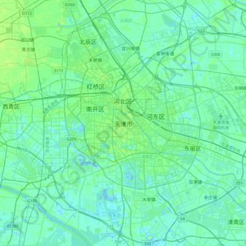
Name: Tianjin topographic map, elevation, terrain.
Location: Tianjin, Heping District, Tianjin, 300050, China (38.95755 117.03130 39.27755 117.35130)
Average elevation: 5 m
Minimum elevation: -5 m
Maximum elevation: 21 m
Tianjin is located along the west coast of the Bohai Gulf, looking out to the provinces Shandong and Liaoning across those waters, bordered by Beijing 120 kilometers (75 mi) to the northwest, and is surrounded on all sides by Hebei, with the exception of its eastern border, the Bohai Sea. With a latitude ranging from 38° 34' to 40° 15' N, and longitude ranging from 116° 43' to 118° 04' E, the total area is 11,860.63 square kilometers (4,579.41 sq mi). There is 153 km (95 mi) of coastline and 1,137.48 kilometers (706.80 mi) of land border. It lies at the northern end of the Grand Canal of China, which connects with the Yellow River and Yangtze River. The municipality is generally flat, and swampy near the coast, but hilly in the far north, where the Yan Mountains intrude into northern Tianjin. Extensive tidal flats occur on the coastal plain adjacent to the city. The highest point in the municipality is Jiuding Peak (九顶山) in Ji County on the northern border with Hebei, at an altitude of 1,078.5 m (3,538 ft).