
Portland Downtown topographic map
Interactive map
Click on the map to display elevation.
About this map
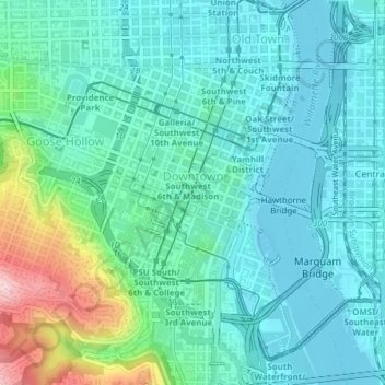
Name: Portland Downtown topographic map, elevation, terrain.
Location: Portland Downtown, Portland, Multnomah County, Oregon, USA (45.50519 -122.68945 45.52307 -122.66879)
Average elevation: 50 m
Minimum elevation: 2 m
Maximum elevation: 230 m
Other topographic maps
Click on a map to view its topography, its elevation and its terrain.
Mount Tabor
Mount Tabor, Portland, Multnomah County, Oregon, 97215, USA
Average elevation: 86 m
Hosford-Abernethy
Hosford-Abernethy, Portland, Multnomah County, Oregon, USA
Average elevation: 26 m