
Kerguelen Archipelago topographic map
Interactive map
Click on the map to display elevation.
Kerguelen Archipelago
The highest point is Mont Ross in the Gallieni Massif, which rises along the southern coast of the island and has an elevation of 1,850 metres (6,070 ft). The Cook Ice Cap (French: Calotte Glaciaire Cook), France's largest glacier with an area of about 403 km2 (156 sq mi), lies on the west-central part of the island. Overall, the glaciers of the Kerguelen Islands cover just over 500 km2 (190 sq mi). Grande Terre has also numerous bays, inlets, fjords, and coves, as well as several peninsulas and promontories. The most important ones are listed below.
About this map
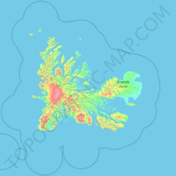
Name: Kerguelen Archipelago topographic map, elevation, terrain.
Average elevation: 38 m
Minimum elevation: -2 m
Maximum elevation: 1,451 m
Other topographic maps
Click on a map to view its topography, its elevation and its terrain.
La mare aux éléphants
France > French Southern and Antarctic Lands > Martin-de-Viviès
Average elevation: 40 m