
Muskegon topographic map
Interactive map
Click on the map to display elevation.
About this map
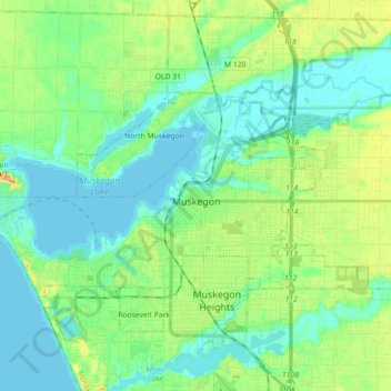
Name: Muskegon topographic map, elevation, terrain.
Location: Muskegon, Muskegon County, Michigan, United States (43.20236 -86.34820 43.26970 -86.16937)
Average elevation: 188 m
Minimum elevation: 175 m
Maximum elevation: 219 m
Other topographic maps
Click on a map to view its topography, its elevation and its terrain.
Muskegon River - South Channel
United States > Michigan > Muskegon County > Muskegon
Muskegon River - South Channel, Muskegon, Muskegon Charter Township, Muskegon County, Michigan, United States
Average elevation: 188 m
Turtle Valley
United States > Michigan > Muskegon County
Turtle Valley, Blue Lake Township, Muskegon County, Michigan, United States
Average elevation: 205 m