
Christiansburg topographic map
Interactive map
Click on the map to display elevation.
About this map
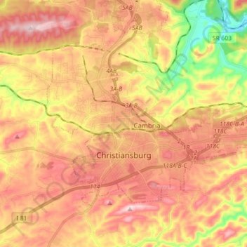
Name: Christiansburg topographic map, elevation, terrain.
Location: Christiansburg, Montgomery County, Virginia, United States (37.10702 -80.45340 37.18082 -80.31440)
Average elevation: 620 m
Minimum elevation: 433 m
Maximum elevation: 757 m
Other topographic maps
Click on a map to view its topography, its elevation and its terrain.
Blacksburg
United States > Virginia > Montgomery County
Blacksburg, Montgomery County, Virginia, United States
Average elevation: 621 m