
Gembloux topographic map
Interactive map
Click on the map to display elevation.
About this map
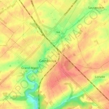
Name: Gembloux topographic map, elevation, terrain.
Location: Gembloux, Gembloers, Namen, Wallonië, 5030, België (50.54036 4.67056 50.58405 4.72224)
Average elevation: 158 m
Minimum elevation: 123 m
Maximum elevation: 179 m
Other topographic maps
Click on a map to view its topography, its elevation and its terrain.
Sauvenière
België > Namen > Namen > Gembloers
Sauvenière, Gembloers, Namen, Wallonië, België
Average elevation: 159 m
Corroy-le-Château
België > Namen > Namen > Gembloers
Corroy-le-Château, Gembloers, Namen, Wallonië, België
Average elevation: 158 m