
Grand Lake topographic map
Interactive map
Click on the map to display elevation.
About this map
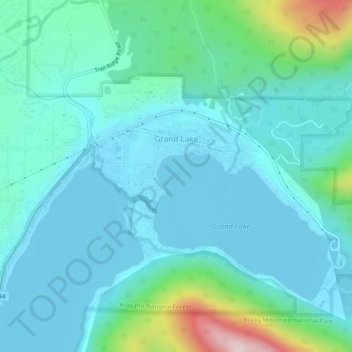
Name: Grand Lake topographic map, elevation, terrain.
Location: Grand Lake, Grand County, Colorado, United States (40.23787 -105.84483 40.25877 -105.79689)
Average elevation: 2,630 m
Minimum elevation: 2,552 m
Maximum elevation: 3,013 m
Established in 1881, Grand Lake sits at an elevation of 8,369 feet (2,551 m) and derives its name from the lake on whose shores it is situated: Grand Lake, the largest natural body of water in Colorado. The town of Grand Lake was originally an outfitting and supply point for the mining settlements of Lulu City, Teller City, and Gaskill, but today is a tourist destination adjacent to the western entrance to Rocky Mountain National Park, which surrounds the lake and the town on three sides. Grand Lake was the Grand County seat of government from 1882 to 1888. It was incorporated on June 23, 1944.
Other topographic maps
Click on a map to view its topography, its elevation and its terrain.
Morse Mountain
United States > Colorado > Grand County
Morse Mountain, Grand County, Colorado, United States
Average elevation: 2,924 m
Fraser
United States > Colorado > Grand County
Fraser, Grand County, Colorado, 80442, United States
Average elevation: 2,696 m
Winter Park
United States > Colorado > Grand County
Winter Park, Grand County, Colorado, United States
Average elevation: 3,068 m
Lake Granby
United States > Colorado > Grand County
Lake Granby, Grand County, Colorado, United States
Average elevation: 2,608 m
Granby
United States > Colorado > Grand County
Granby, Grand County, Colorado, United States
Average elevation: 2,555 m
Rabbit Ears Pass
United States > Colorado > Grand County
Rabbit Ears Pass, Grand County, Colorado, United States
Average elevation: 2,852 m
Bottle Peak
United States > Colorado > Grand County
Bottle Peak, Grand County, Colorado, United States
Average elevation: 3,283 m
Elk Mountain
United States > Colorado > Grand County
Elk Mountain, Grand County, Colorado, United States
Average elevation: 3,218 m
Tabernash
United States > Colorado > Grand County
Tabernash, Grand County, Colorado, 80478, United States
Average elevation: 2,592 m
Kremmling
United States > Colorado > Grand County
Kremmling, Grand County, Colorado, 80459, United States
Average elevation: 2,251 m
Mount Flora
United States > Colorado > Grand County
Mount Flora, Grand County, Colorado, United States
Average elevation: 3,728 m
Indian Peaks Wilderness
United States > Colorado > Grand County
Indian Peaks Wilderness, Grand County, Colorado, United States
Average elevation: 3,080 m