
Leicestershire topographic map
Interactive map
Click on the map to display elevation.
About this map
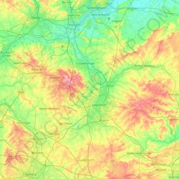
Name: Leicestershire topographic map, elevation, terrain.
Location: Leicestershire, Angleterre, Royaume-Uni (52.39217 -1.59755 52.97766 -0.66411)
Average elevation: 98 m
Minimum elevation: 16 m
Maximum elevation: 269 m
La partie nord-ouest du comté, au niveau de Coalville, héberge la National Forest qui s'étend également dans le Derbyshire et le Staffordshire. L'altitude du Leicestershire est comprise entre 20 et 278 mètres, et son point culminant est Bardon Hill.
Other topographic maps
Click on a map to view its topography, its elevation and its terrain.
Melton Mowbray
Royaume-Uni > Angleterre > Leicestershire > Melton
Melton Mowbray, Melton, Leicestershire, Angleterre, LE13 0PU, Royaume-Uni
Average elevation: 103 m
North West Leicestershire
Royaume-Uni > Angleterre > Leicestershire
North West Leicestershire, Leicestershire, Angleterre, Royaume-Uni
Average elevation: 101 m
Wycomb
Royaume-Uni > Angleterre > Leicestershire > Melton > Scalford
Wycomb, Scalford, Melton, Leicestershire, Angleterre, LE14 4QG, Royaume-Uni
Average elevation: 132 m