
Pembroke topographic map
Interactive map
Click on the map to display elevation.
About this map
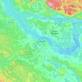
Name: Pembroke topographic map, elevation, terrain.
Location: Pembroke, Eastern Ontario, Ontario, K8A 4K2, Canada (45.66609 -77.27354 45.98609 -76.95354)
Average elevation: 157 m
Minimum elevation: 104 m
Maximum elevation: 408 m
Other topographic maps
Click on a map to view its topography, its elevation and its terrain.
Riverside Park
Canada > Ontario > Pembroke > Pembroke
Riverside Park, Pembroke, Eastern Ontario, Ontario, Canada
Average elevation: 121 m