
Berwick-upon-Tweed topographic map
Interactive map
Click on the map to display elevation.
Berwick-upon-Tweed
In 1707, the Act of Union between England and Scotland largely ended the contention about which of the countries Berwick belonged to. Since then, Berwick remained within the laws and legal system of England and Wales. The Wales and Berwick Act 1746 (since repealed) deemed that whenever legislation referred to England it applied to Berwick. In the 1840s, Samuel Lewis included similar entries for Berwick-upon-Tweed in both his England and Scotland Topographical Dictionary. Berwick remained a county in its own right, and was not included in Northumberland for Parliamentary purposes until 1885. In the same year, the Redistribution of Seats Act reduced the number of Members of Parliament (MPs) returned by the town from two to one.
About this map
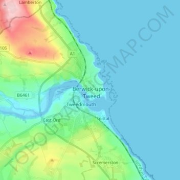
Name: Berwick-upon-Tweed topographic map, elevation, terrain.
Average elevation: 36 m
Minimum elevation: -1 m
Maximum elevation: 197 m