
Nassau topographic map
Interactive map
Click on the map to display elevation.
About this map
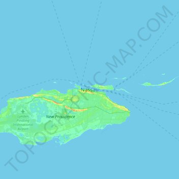
Name: Nassau topographic map, elevation, terrain.
Location: Nassau, New Providence, Bahamas (24.91823 -77.49834 25.23823 -77.17834)
Average elevation: 1 m
Minimum elevation: 0 m
Maximum elevation: 35 m
Other topographic maps
Click on a map to view its topography, its elevation and its terrain.
Bahamas
The topography of the Bahamas is primarily flat and low-lying, characterized by limestone formations, sandy beaches, and a unique geological feature known as the Great Bahama Bank. Most of the islands have elevations that seldom rise above 30 feet (9 meters) above sea level, with the terrain generally ranging…
Average elevation: 9 m
Bahamas
According to the Köppen climate classification, the climate of the Bahamas is mostly tropical savannah climate or Aw, with a hot and wet season and a warm and dry season. The low latitude, warm tropical Gulf Stream, and low elevation give the Bahamas a warm and winterless climate.
Average elevation: 9 m
Bahamas
According to the Köppen climate classification, the climate of The Bahamas is mostly tropical savannah climate or Aw, with a hot and wet season and a warm and dry season. The low latitude, warm tropical Gulf Stream, and low elevation give The Bahamas a warm and winterless climate.
Average elevation: 9 m