
Kartuzy topographic map
Interactive map
Click on the map to display elevation.
Kartuzy
Kartuzy is located about 32 kilometres (20 miles) west of Gdańsk and 35 km (22 miles) south-east of the town of Lębork on a plateau at an altitude of approximately 200 metres (656 feet) above sea level in the average. The plateau, which is divided by the Radaune lake, comprises the highest parts of the Baltic Sea Plate. In the west of this lake are the highest points of the headwaters of rivers Łeba, Słupia and Bukowina at an altitude of up to 271 metres (889 feet). A hill in the south of the lake is 331 metres (1,086 feet) high.
About this map
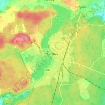
Name: Kartuzy topographic map, elevation, terrain.
Average elevation: 217 m
Minimum elevation: 171 m
Maximum elevation: 265 m
Other topographic maps
Click on a map to view its topography, its elevation and its terrain.