Geolocate

Mount Kembla topographic map

Interactive map

Click on the map to display elevation.

About this map

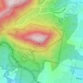
Name: Mount Kembla topographic map, elevation, terrain.

Location: Mount Kembla, Wollongong, Wollongong City Council, New South Wales, 2526, Australia (-34.44223 150.80666 -34.44213 150.80676)

Average elevation: 227 m

Minimum elevation: 30 m

Maximum elevation: 528 m

The summit of Mount Kembla has an elevation of 534 metres (1,752 ft) above sea level.

Other topographic maps

Click on a map to view its topography, its elevation and its terrain.

Port Kembla

Australia > New South Wales > Wollongong

Port Kembla, Wollongong, Wollongong City Council, New South Wales, 2505, Australia

Average elevation: 10 m