
Abu Dhabi topographic map
Interactive map
Click on the map to display elevation.
About this map
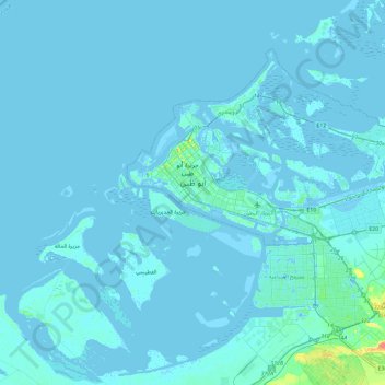
Name: Abu Dhabi topographic map, elevation, terrain.
Location: Abu Dhabi, Abu Dhabi Emirate, United Arab Emirates (24.28103 54.29716 24.60185 54.76591)
Average elevation: 2 m
Minimum elevation: -10 m
Maximum elevation: 44 m
Other topographic maps
Click on a map to view its topography, its elevation and its terrain.
Al Ain
United Arab Emirates > Abu Dhabi Emirate > Al Ain > Al Ain
Al Ain is located approximately 160 kilometres (99 mi) east of the capital Abu Dhabi, and about 120 kilometres (75 mi) south of Dubai. The eastern region covers an area of approximately 13,100 km2 (5,100 sq mi). Oman lies to the east, Dubai and Sharjah to the north, Abu Dhabi to the west and the Empty Quarter…
Average elevation: 295 m
Sha'ab Al Ashkher
United Arab Emirates > Abu Dhabi Emirate > Al Ain > Shiab Al Ashkhar > Sha'ab Al Ashkher
Average elevation: 266 m