
Limón Province topographic map
Interactive map
Click on the map to display elevation.
Limón Province
The majority of Limón's land lies at sea level, though its western border sees an increase in altitude due largely to the Cordillera de Talamanca. The province's indigenous populations largely reside in reserves that occupy much of the cantón of Talamanca.
About this map
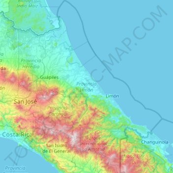
Name: Limón Province topographic map, elevation, terrain.
Location: Limón Province, Costa Rica (9.07516 -83.94751 11.12492 -82.42990)
Average elevation: 435 m
Minimum elevation: -1 m
Maximum elevation: 3,743 m
Other topographic maps
Click on a map to view its topography, its elevation and its terrain.
Arenal Volcano
Costa Rica > Alajuela Province > Cantón San Carlos > La Fortuna
Average elevation: 1,014 m