
Maputo topographic map
Interactive map
Click on the map to display elevation.
About this map
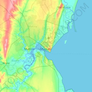
Name: Maputo topographic map, elevation, terrain.
Location: Maputo, Zona Sul, Mozambique (-26.09002 32.43997 -25.81171 32.99367)
Average elevation: 23 m
Minimum elevation: -3 m
Maximum elevation: 120 m
Other topographic maps
Click on a map to view its topography, its elevation and its terrain.
Gogogo
Mount Gorongosa is an inselberg in Sofala Province of central Mozambique. Its highest peak, Gogogo, reaches an elevation of 1,863 meters (6,112 feet). It was created by Karoo Volcanism.
Average elevation: 1,419 m
Xai-Xai
Xai-Xai is located close to the Indian Ocean, on the Limpopo River. It is 200 kilometres (120 mi) from the capital, Maputo, and is in a wide, fertile plain where rice is grown. It is at an elevation of 9.8 m (32 ft).
Average elevation: 19 m
Bazaruto
The warm, southward-flowing Mozambique Current seems to contribute to the increasing buildup of the sandy coastline. Because the water along this coastal area is very clear, much of the sub-surface channel pattern around the island is discernible. Several narrow lines of plankton bloom parallel the shoreline…
Average elevation: 2 m