Geolocate

Monroe County topographic map

Interactive map

Click on the map to display elevation.

About this map

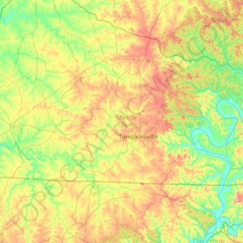
Name: Monroe County topographic map, elevation, terrain.

Location: Monroe County, Kentucky, United States of America (36.61499 -85.97704 36.84161 -85.43633)

Average elevation: 250 m

Minimum elevation: 156 m

Maximum elevation: 414 m

Other topographic maps

Click on a map to view its topography, its elevation and its terrain.

Warfield

United States of America > Kentucky > Warfield

Warfield, Martin County, Kentucky, 41267, United States of America

Average elevation: 259 m

Williamstown

United States of America > Kentucky > Williamstown

Williamstown, Grant County, Kentucky, 41097, United States of America

Average elevation: 262 m

Paducah

United States of America > Kentucky > Paducah

Paducah, McCracken County, Kentucky, United States of America

Average elevation: 108 m

Cumberland County

United States of America > Kentucky

Cumberland County, Kentucky, United States of America

Average elevation: 237 m

Yosemite

United States of America > Kentucky > Yosemite

Yosemite, Casey County, Kentucky, 42541, United States of America

Average elevation: 285 m