
Mainz topographic map
Interactive map
Click on the map to display elevation.
Mainz
Nevertheless, the post-war reconstruction took place very slowly. While cities such as Frankfurt had been rebuilt fast by a central authority, only individual efforts were initially successful in rebuilding Mainz. The reason for this was that the French wanted Mainz to expand and to become a model city. Mainz lay within the French-controlled sector of Germany and it was a French architect and town-planner, Marcel Lods, who produced a Le Corbusier-style plan of an ideal architecture. But the very first interest of the inhabitants was the restoration of housing areas. Even after the failure of the model city plans it was the initiative of the French (founding of the Johannes Gutenberg University of Mainz, elevation of Mainz to the state capital of Rhineland-Palatinate, the early resumption of the Mainz carnival) driving the city in a positive development after the war. The City Plan of 1958 by Ernst May allowed a regulated reconstruction for the first time. In 1950, the seat of the government of Rhineland-Palatinate had been transferred to the new Mainz and in 1963 the seat of the new ZDF, notable architects were Adolf Bayer, Richard Jörg and Egon Hartmann. At the time of the two-thousand-years-anniversary in 1962 the city was largely reconstructed. During the 1950s and 1960s the Oberstadt had been extended, Münchfeld and Lerchenberg added as suburbs, the Altstadttangente (intersection of the old town), new neighbourhoods as Westring and Südring contributed to the extension. By 1970 there remained only a few ruins. The new town hall of Mainz had been designed by Arne Jacobsen and finished by Dissing+Weitling. The town used Jacobsens activity for the Danish Novo erecting a new office and warehouse building to contact him. The urban renewal of the old town changed the inner city. In the framework of the preparation of the cathedrals millennium, pedestrian zones were developed around the cathedral, in northern direction to the Neubrunnenplatz and in southern direction across the Leichhof to the Augustinerstraße and Kirschgarten. The 1980s brought the renewal of the façades on the Markt and a new inner-city neighbourhood on the Kästrich. During the 1990s the Kisselberg between Gonsenheim and Bretzenheim, the "Fort Malakoff Center" at the site of the old police barracks, the renewal of the Main Station and the demolition of the first post-war shopping center at the Markt followed by the erection of a new historicising building at the same place.
About this map
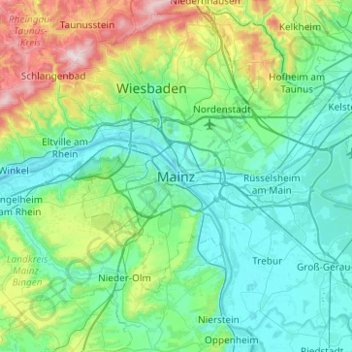
Name: Mainz topographic map, elevation, terrain.
Location: Mainz, Rhineland-Palatinate, 55116, Germany (49.84123 8.11625 50.16123 8.43625)
Average elevation: 183 m
Minimum elevation: 79 m
Maximum elevation: 616 m