
Lumby topographic map
Interactive map
Click on the map to display elevation.
About this map
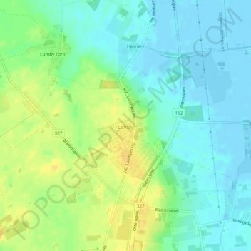
Name: Lumby topographic map, elevation, terrain.
Location: Lumby, Odense Kommune, Region of Southern Denmark, Denmark (55.45165 10.37046 55.46457 10.38191)
Average elevation: 10 m
Minimum elevation: -3 m
Maximum elevation: 25 m
Other topographic maps
Click on a map to view its topography, its elevation and its terrain.
Vester Vedsted
Denmark > Region of Southern Denmark
Vester Vedsted, Esbjerg Municipality, Region of Southern Denmark, Denmark
Average elevation: 3 m
Mandø
Denmark > Region of Southern Denmark > Mandø By
Mandø, Mandø By, Esbjerg Municipality, Region of Southern Denmark, Denmark
Average elevation: 0 m
Vejle
Denmark > Region of Southern Denmark > Vejle
Vejle, Vejle Municipality, Region of Southern Denmark, 7100, Denmark
Average elevation: 60 m
Rudkøbing
Denmark > Region of Southern Denmark > Rudkøbing
Rudkøbing, Langeland Municipality, Region of Southern Denmark, 5900, Denmark
Average elevation: 5 m
Odense
Denmark > Region of Southern Denmark > Odense
Odense, Odense Kommune, Region of Southern Denmark, 5000, Denmark
Average elevation: 30 m
Fyn
Denmark > Region of Southern Denmark > Odense
Fyn, Region of Southern Denmark, Denmark
Average elevation: 19 m
Hugget
Denmark > Region of Southern Denmark > Hugget
Hugget, Nordfyn Municipality, Region of Southern Denmark, Denmark
Average elevation: 11 m