
Chaiyaphum Province topographic map
Interactive map
Click on the map to display elevation.
About this map
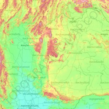
Name: Chaiyaphum Province topographic map, elevation, terrain.
Location: Chaiyaphum Province, Thailand (13.71203 99.15538 18.83203 104.27538)
Average elevation: 245 m
Minimum elevation: 0 m
Maximum elevation: 1,915 m
The province is bisected by the Phetchabun mountain range, with the highest elevation in the province at 1,222 m. The east of the province is part of the Khorat Plateau.
Other topographic maps
Click on a map to view its topography, its elevation and its terrain.
Ban Non Muang
Thailand > Chaiyaphum Province > Ban Non Muang
Ban Non Muang, Chaiyaphum Province, 36260, Thailand
Average elevation: 297 m