
Randa topographic map
Interactive map
Click on the map to display elevation.
About this map
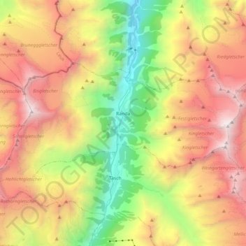
Name: Randa topographic map, elevation, terrain.
Location: Randa, Visp, Wallis, 3928, Switzerland (46.06479 7.68955 46.12600 7.86866)
Average elevation: 2,804 m
Minimum elevation: 1,211 m
Maximum elevation: 4,532 m
Other topographic maps
Click on a map to view its topography, its elevation and its terrain.
Monte Rosa
Switzerland > Wallis > Visp > Zermatt
The peak is distinguished by the name Dufourspitze (in German, lit. Dufour Peak; French: Pointe Dufour, Italian: Punta Dufour). This replaced the former name Höchste Spitze (English: Highest Peak) that was indicated on the Swiss maps before the Federal Council, on January 28, 1863, decided to rename the…
Average elevation: 4,033 m