
Leticia topographic map
Interactive map
Click on the map to display elevation.
About this map
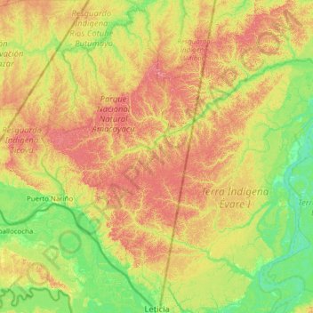
Name: Leticia topographic map, elevation, terrain.
Location: Leticia, Amazonas, RAP Amazonía, Colombia (-4.22940 -70.36640 -3.00236 -69.71408)
Average elevation: 97 m
Minimum elevation: 50 m
Maximum elevation: 183 m
Other topographic maps
Click on a map to view its topography, its elevation and its terrain.
Leticia
Leticia (Spanish pronunciation: [leˈtisja]) is the southernmost city in the Republic of Colombia, capital of the department of Amazonas, Colombia's southernmost town (4.09° south 69.57° west) and one of the major ports on the Amazon River. It has an elevation of 96 meters (315') above sea level and an…
Average elevation: 71 m