
Skikda topographic map
Interactive map
Click on the map to display elevation.
About this map
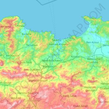
Name: Skikda topographic map, elevation, terrain.
Location: Skikda, Algeria (36.41932 6.23928 37.08985 7.40537)
Average elevation: 317 m
Minimum elevation: -1 m
Maximum elevation: 1,399 m
Other topographic maps
Click on a map to view its topography, its elevation and its terrain.
Ain Bouziane
Algeria > Skikda > Sidi Mezghiche District
Ain Bouziane, Sidi Mezghiche District, Skikda, Algeria
Average elevation: 413 m