
Kanchanaburi Province topographic map
Interactive map
Click on the map to display elevation.
Kanchanaburi Province
The province is in the west of Thailand, 129 km from Bangkok, and covers a total area of approximately 19,483 km². It is the country's third largest province, after Nakhon Ratchasima and Chiang Mai. Topographically, it is covered with timber and evergreen forests. The district covers the source valleys of the rivers Kwae Yai and Kwae Noi ("River Kwai"), which merge at Kanchanaburi city to form the Mae Klong River.
About this map
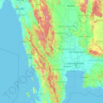
Name: Kanchanaburi Province topographic map, elevation, terrain.
Location: Kanchanaburi Province, Thailand (11.88019 96.70767 17.00019 101.82767)
Average elevation: 153 m
Minimum elevation: -2 m
Maximum elevation: 2,024 m