Geolocate

Kincardine topographic map

Interactive map

Click on the map to display elevation.

About this map

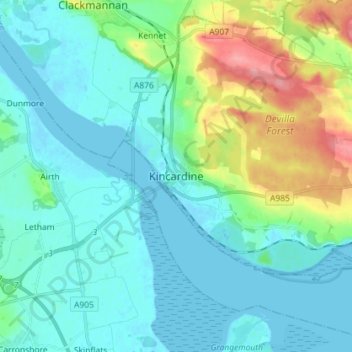
Name: Kincardine topographic map, elevation, terrain.

Location: Kincardine, Fife, Scotland, FK10 4NE, United Kingdom (56.02840 -3.75846 56.10840 -3.67846)

Average elevation: 22 m

Minimum elevation: -3 m

Maximum elevation: 103 m

Other topographic maps

Click on a map to view its topography, its elevation and its terrain.

St Andrews

United Kingdom > Scotland > Fife

St Andrews, Fife, Scotland, KY16 9PA, United Kingdom

Average elevation: 38 m

Kirkcaldy

United Kingdom > Scotland > Fife

Kirkcaldy, Fife, Scotland, KY1 1JA, United Kingdom

Average elevation: 50 m

Glenrothes

United Kingdom > Scotland > Fife

Glenrothes, Fife, Scotland, KY7 5LW, United Kingdom

Average elevation: 106 m

Freuchie

United Kingdom > Scotland > Fife

Freuchie, Fife, Scotland, KY15 7EJ, United Kingdom

Average elevation: 78 m

Elie and Earlsferry

United Kingdom > Scotland > Fife > Elie and Earlsferry

Elie and Earlsferry, Fife, Scotland, KY9 1BD, United Kingdom

Average elevation: 10 m

Falkland

United Kingdom > Scotland > Fife

Falkland, Fife, Scotland, KY15 7BU, United Kingdom

Average elevation: 133 m