
Latina topographic map
Interactive map
Click on the map to display elevation.
Latina
The mainland area is, in the south- and north-eastern part, mostly occupied by limestone hills and mountains. Ranges include the Lepini, Aurunci, Ausoni. The highest elevation is that of 1,533-metre (5,030 ft) Monte Petrella (Aurunci). The climate is semi-continental with hot summers and cold winters; temperatures rarely fall below 0 °C (32 °F). The mountains are characterized by small medieval settlements (borghi) and traditionally live of cattle raising and agriculture; however, these activities saw a marked decline in recent times, and today workers usually commute daily to work in Rome or Latina. Tourism is an increasing interesting resource, attracted especially by the uncontaminated nature and by artistic traces of the Middle Ages (Abbeys of Valvisciolo and Fossanova, where St. Thomas Aquinas died). The main centres of this area are Cori, Sezze, and Priverno.
About this map
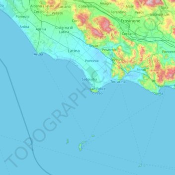
Name: Latina topographic map, elevation, terrain.
Location: Latina, Lazio, Italy (40.78493 12.53016 41.71483 13.89481)
Average elevation: 103 m
Minimum elevation: -3 m
Maximum elevation: 1,729 m
Other topographic maps
Click on a map to view its topography, its elevation and its terrain.
Monte Cassino
Italy > Lazio > Frosinone > Cassino
Monte Cassino (today usually spelled Montecassino) is a rocky hill about 130 kilometres (80 mi) southeast of Rome, in the Latin Valley, Italy, 2 kilometres (1+1⁄4 mi) west of Cassino and at an elevation of 520 m (1,710 ft). Site of the Roman town of Casinum, it is widely known for its abbey, the first house…
Average elevation: 231 m
Melfa
Italy > Lazio > Casalattico
The source of the Melfa issues from a high limestone chimney in the Valle di Canneto at an elevation of 1,020 metres (3,350 ft) in the Lazio watershed of the Parco Nazionale d'Abruzzo, Lazio e Molise beneath the Massiccio del Meta, in the territory of Settefrati. The source has been linked in local legend and…
Average elevation: 423 m