Geolocate

Breezy Point topographic map

Interactive map

Click on the map to display elevation.

About this map

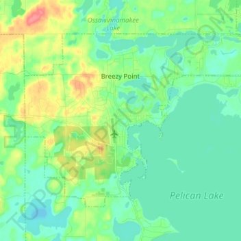
Name: Breezy Point topographic map, elevation, terrain.

Location: Breezy Point, Crow Wing County, Minnesota, United States (46.56995 -94.26690 46.63174 -94.14191)

Average elevation: 377 m

Minimum elevation: 360 m

Maximum elevation: 421 m

Other topographic maps

Click on a map to view its topography, its elevation and its terrain.

Duck Lake

United States > Minnesota > Crow Wing County > Crosslake

Duck Lake, Crosslake, Crow Wing County, Minnesota, United States

Average elevation: 377 m

Ruth Lake

United States > Minnesota > Crow Wing County > Emily

Ruth Lake, Emily, Crow Wing County, Minnesota, United States

Average elevation: 391 m

Pequot Terrace

United States > Minnesota > Crow Wing County > Nisswa

Pequot Terrace, Nisswa, Crow Wing County, Minnesota, 56468, United States

Average elevation: 372 m

Saint Mathias

United States > Minnesota > Crow Wing County > Saint Mathias

Saint Mathias, Crow Wing County, Minnesota, United States

Average elevation: 369 m

Emily

United States > Minnesota > Crow Wing County > Emily

Emily, Crow Wing County, Minnesota, 56447, United States

Average elevation: 393 m

Brainerd

United States > Minnesota > Crow Wing County

Brainerd, Crow Wing County, Minnesota, 56401, United States

Average elevation: 370 m