
Cleveland National Forest topographic map
Interactive map
Click on the map to display elevation.
About this map
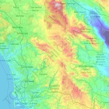
Name: Cleveland National Forest topographic map, elevation, terrain.
Average elevation: 596 m
Minimum elevation: -71 m
Maximum elevation: 3,198 m
Other topographic maps
Click on a map to view its topography, its elevation and its terrain.
Mammoth Lakes
United States of America > California > Mammoth Lakes
Mammoth Lakes is a town in Mono County, California, the county's only incorporated community. It is located immediately to the east of Mammoth Mountain, at an elevation of 7,880 feet (2,400 m). As of the 2010 United States Census, the population was 8,234, reflecting a 16% increase from the 2000 Census.
Average elevation: 2,184 m
Pinyon Pines
United States of America > California > Pinyon Pines
It is located in a small valley between the San Jacinto Mountains and Santa Rosa Mountains, north of State Route 74. It takes its name from the Pinyon pine (Pinus monophylla) trees native to the area. Pinyon Pines sits at an elevation of approximately 4000 feet.
Average elevation: 1,276 m
Rancho Santa Fe
United States of America > California > Rancho Santa Fe
The climate of Rancho Santa Fe is, for the most part, typical of the San Diego metropolitan area though its higher elevation and inland location lends itself to larger temperature variations.
Average elevation: 68 m
Santa Nella Village
United States of America > California > Santa Nella Village
Average elevation: 50 m
Las Positas Meadows
United States of America > California > Santa Barbara > Las Positas Meadows
Average elevation: 66 m
Grass Valley
United States of America > California > Grass Valley
Grass Valley is a city in Nevada County, California, United States. Situated at roughly 2,500 feet (760 m) elevation in the western foothills of the Sierra Nevada mountain range, this historic northern Gold Country city is 57 miles (92 km) by car from the state capitol in Sacramento, 64 miles (103 km) from…
Average elevation: 767 m
Miracle Hot Springs
United States of America > California > Miracle Hot Springs
Average elevation: 927 m
San Luis Rey Heights
United States of America > California > Bonsall > San Luis Rey Heights
Average elevation: 115 m