
Cortes Island topographic map
Interactive map
Click on the map to display elevation.
About this map
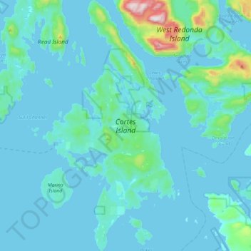
Name: Cortes Island topographic map, elevation, terrain.
Average elevation: 72 m
Minimum elevation: -2 m
Maximum elevation: 954 m
Strathcona Regional District trails, hiking, mountain biking, running and outdoor activities
Other topographic maps
Click on a map to view its topography, its elevation and its terrain.
Whaletown
Canada > British Columbia > Strathcona Regional District > Area C (Cortes Island)
Average elevation: 26 m
Protection Island
Canada > British Columbia > Strathcona Regional District > Area C (Cortes Island)
Average elevation: 36 m