
K2 topographic map
Interactive map
Click on the map to display elevation.
K2
K2 is the only 8,000+ metre peak that has never been climbed from its eastern face. Ascents have almost always been made in July and August, which are typically the warmest times of the year; K2's more northern location makes it more susceptible to inclement and colder weather. The peak has now been climbed by almost all of its ridges. Although the summit of Everest is at a higher altitude, K2 is a more difficult and dangerous climb, due in part to its more inclement weather. As of February 2021, only 377 people have completed the ascent to its summit. There have been 91 deaths during attempted climbs, according to the list maintained on the list of deaths on eight-thousanders.
About this map
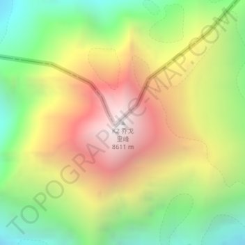
Name: K2 topographic map, elevation, terrain.
Average elevation: 7,474 m
Minimum elevation: 6,440 m
Maximum elevation: 8,611 m
Other topographic maps
Click on a map to view its topography, its elevation and its terrain.
Biafo Glacier
Pakistan > Gilgit-Baltistan > Shigar District
Biafo Glacier converging at Hispar La with 49 kilometres (30 mi) long Hispar Glacier situated at an elevation of 5,128 metres (16,824 ft), forms the glacial system considered as the world's longest non-polar glacial system which spans an overall distance of around 120 kilometres (75 mi). This frozen pathway…
Average elevation: 4,618 m