
Barren Island topographic map
Interactive map
Click on the map to display elevation.
About this map
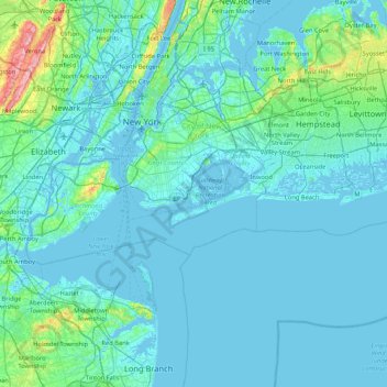
Name: Barren Island topographic map, elevation, terrain.
Average elevation: 16 m
Minimum elevation: -6 m
Maximum elevation: 207 m
Other topographic maps
Click on a map to view its topography, its elevation and its terrain.
East Village
USA > New York > New York City
East Village, Manhattan, Manhattan Community Board 3, New York County, New York City, New York, USA
Average elevation: 15 m
Meatpacking District
USA > New York > New York City
Meatpacking District, Manhattan, Manhattan Community Board 2, New York County, New York City, New York, 100014, USA
Average elevation: 9 m
East River
USA > New York > New York City
East River, New York County, New York City, New York, 10044, USA
Average elevation: 15 m
Governors Island
USA > New York > New York City
Governors Island, Manhattan Community Board 1, New York County, New York City, New York, USA
Average elevation: 1 m
Chelsea
USA > New York > New York City
Chelsea, Manhattan, Manhattan Community Board 4, New York County, New York City, New York, USA
Average elevation: 13 m
SoHo
USA > New York > New York City
SoHo, Manhattan, Manhattan Community Board 2, New York County, New York City, New York, 10012, USA
Average elevation: 15 m
Midtown East
USA > New York > New York City
Midtown East, Manhattan, Manhattan Community Board 5, New York County, New York City, New York, USA
Average elevation: 22 m