
Suzhou City topographic map
Interactive map
Click on the map to display elevation.
About this map
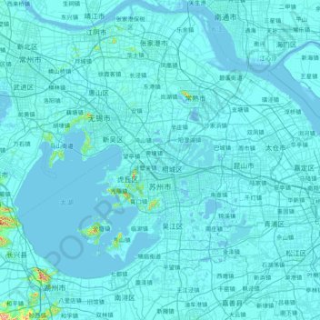
Name: Suzhou City topographic map, elevation, terrain.
Location: Suzhou City, Jiangsu, China (30.76033 119.91621 32.04578 121.38225)
Average elevation: 6 m
Minimum elevation: -4 m
Maximum elevation: 509 m
Other topographic maps
Click on a map to view its topography, its elevation and its terrain.
Nanjing
There are mainly two types of soil in Nanjing: zonal soil and cultivated soil. The zonal soil is yellow-brown soil in the northern and central areas of Nanjing, and red soil in the southern part of the border with Anhui. The cultivated soil formed by man-made farming is mainly paddy soil, and there are some…
Average elevation: 25 m