
Addison County topographic map
Interactive map
Click on the map to display elevation.
About this map
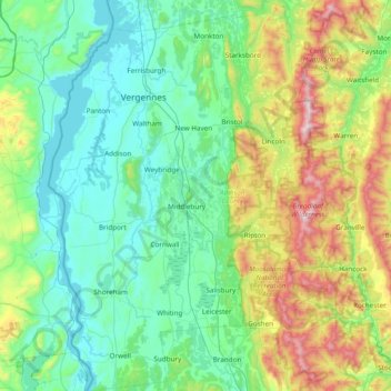
Name: Addison County topographic map, elevation, terrain.
Location: Addison County, Vermont, United States of America (43.75308 -73.43774 44.30374 -72.74224)
Average elevation: 287 m
Minimum elevation: 23 m
Maximum elevation: 1,222 m
Other topographic maps
Click on a map to view its topography, its elevation and its terrain.
Brookwood Estates
United States of America > Vermont > Rutland > Brookwood Estates
Average elevation: 359 m