
Namakwa District Municipality topographic map
Interactive map
Click on the map to display elevation.
About this map
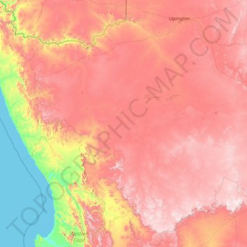
Name: Namakwa District Municipality topographic map, elevation, terrain.
Location: Namakwa District Municipality, Northern Cape, South Africa (-32.94500 16.45194 -28.03276 22.20628)
Average elevation: 793 m
Minimum elevation: 0 m
Maximum elevation: 1,905 m
Other topographic maps
Click on a map to view its topography, its elevation and its terrain.
Sutherland
South Africa > Northern Cape > Namakwa District Municipality > Karoo Hoogland Local Municipality
Average elevation: 1,533 m
Antjie Boom se Baken
South Africa > Northern Cape > Namakwa District Municipality > Hantam Local Municipality
Average elevation: 1,049 m
Lime Acres
South Africa > Northern Cape > ZF Mgcawu District Municipality > Kgatelopele Local Municipality
Average elevation: 1,496 m
Fraserburg
South Africa > Northern Cape > Namakwa District Municipality > Karoo Hoogland Local Municipality
Fraserburg is situated at an altitude of 1,385 metres (4,544 ft) above sea level on a high Karoo plateau, north of the Nuweveld Mountains.
Average elevation: 1,268 m
Springbok
South Africa > Northern Cape > Namakwa District Municipality > Nama Khoi Local Municipality > Springbok
Average elevation: 926 m
Hopetown
South Africa > Northern Cape > Thembelihle Local Municipality > Hopetown
Average elevation: 1,101 m