
Thank you for supporting this site ❤️
Make a donation
Make a donation
Gear up for your next adventure:
As an Amazon Associate, this site earns from qualifying purchases at no extra cost to you.
Lumsden topographic map
Click on the map to display elevation.
Gear up for your next adventure:
As an Amazon Associate, this site earns from qualifying purchases at no extra cost to you.
About this map
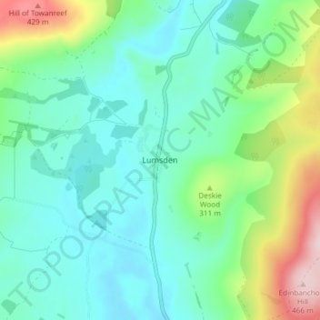
Name: Lumsden topographic map, elevation, terrain.
Location: Lumsden, Aberdeenshire, Scotland, AB54 4JF, United Kingdom (57.26556 -2.89365 57.30556 -2.85365)
Average elevation: 262 m
Minimum elevation: 194 m
Maximum elevation: 468 m
Thank you for supporting this site ❤️
Make a donation
Make a donation
Gear up for your next adventure:
As an Amazon Associate, this site earns from qualifying purchases at no extra cost to you.