
Pueblo topographic map
Interactive map
Click on the map to display elevation.
About this map
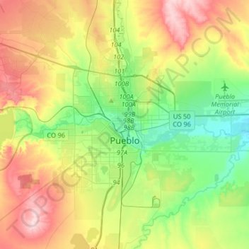
Name: Pueblo topographic map, elevation, terrain.
Location: Pueblo, Pueblo County, Colorado, United States (38.18911 -104.72227 38.34537 -104.46004)
Average elevation: 1,487 m
Minimum elevation: 1,393 m
Maximum elevation: 1,629 m
Pueblo has a steppe climate (Köppen BSk), with four distinct seasons. Winter days are usually mild, but the high does not surpass freezing on an average 14.4 days per year, and lows fall to 0 °F (−18 °C) or below on 6.2 nights. Snowfall usually falls in light amounts, and due to the high altitude, and the accompanying stronger sun, rarely remains on the ground for long (typically, for one or two days). January is the snowiest month, and the seasonal average is 28.3 inches (72 cm); however, snow is uncommon in October, and in May or September, snow is exceedingly rare, with an average first and last date of measurable (≥0.1 in or 0.25 cm) snowfall being November 4 and April 9, respectively. Summers are hot and dry, with 90 °F (32 °C) or greater highs are on average seen 71.6 days per year, with 100 °F (38 °C) or greater on 12.0 days. Diurnal temperature ranges are large throughout the year, averaging 32.5 °F (18.1 °C).
Other topographic maps
Click on a map to view its topography, its elevation and its terrain.
Beulah
United States > Colorado > Pueblo County > Beulah
Beulah, Pueblo County, Colorado, 81023, United States
Average elevation: 2,013 m