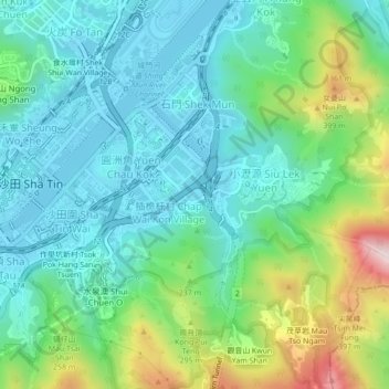
Ngau Pei Sha Village topographic map
Interactive map
Click on the map to display elevation.
About this map
Name: Ngau Pei Sha Village topographic map, elevation, terrain.
Average elevation: 142 m
Minimum elevation: -4 m
Maximum elevation: 546 m

Click on the map to display elevation.
Name: Ngau Pei Sha Village topographic map, elevation, terrain.
Average elevation: 142 m
Minimum elevation: -4 m
Maximum elevation: 546 m